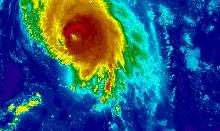
Cyclone Chapala expert comment: Yemen prepares for 'onslaught of rain'
Release Date 30 October 2015

Professor Pier Luigi Vidale, professor of climate system science, University of Reading, said:
"Cyclone Chapala is likely to strengthen to become at the lower end of a Category 5 storm over the next day, but is likely to weaken to a Category 1 cyclone before it makes landfall on Monday.
"Of course, the crucial issue is where it makes landfall and what falls in its path. With up to half a metre of rain forecast in an area only used to getting a couple of centimetres in a year, the risk of flooding could be the greatest problem.
"Recent research has suggested that a warming climate could be bringing an increased risk of big storms to the Gulf region."
Dr Chris Holloway, a tropical storm expert at the University of Reading, said:
"Cyclone Chapala is very unusual. It is rare to have such a strong storm in this part of the world. Chapala is likely to end up being the most intense cyclone recorded in the Arabian Sea, and possibly the Northern Indian Ocean, if it intensifies a bit more, as is forecast. However, satellite measurements of storms in the Arabian Sea go back only a few decades, and there are no available direct measurements from aircraft.
Heavy rains could cause severe flooding in areas that very rarely see sustained heavy rainfall - Chris Holloway
"Like Hurricane Patricia in Mexico last week, this storm is compact. The hurricane force winds extend about 35 miles from the centre, which would limit the region of wind damage at landfall. Most forecasts are suggesting the storm will strengthen in the next 24 hours, but then it should weaken before landfall around Monday, perhaps to a Category 1 or Category 2 storm. This would still mean sustained winds of between 74mph and 110mph - enough to cause significant damage, especially if it hits an area where buildings are not designed for such an onslaught. Heavy rains could cause severe flooding in areas that very rarely see sustained heavy rainfall.
"This weakening is forecast because of decreasing atmospheric humidity and decreasing ocean heat content in the later part of its journey towards the Arabian peninsula. The current track brings it onshore near the border region between Oman and Yemen, which is less densely populated than western Yemen."
Dr Ray Bell, tropical storm expert at the University of Reading, said:
"While the strong El Nino event causes more tropical storms to form in the Pacific Ocean, it makes tropical storms in the Northern Indian Ocean less likely. Therefore Super Cyclone Chapala does not fit the picture, particularly because it is so intense.
Chapala is likely to be the strongest cyclone to make landfall in Yemen since records began - Ray Bell
"Chapala is likely to be the strongest cyclone to make landfall in Yemen since records began with wind speeds forecast at 90mph.
"A storm in October 2008, which only had wind speeds of 30mph, was associated with widespread flooding which displaced 22,000 people and killed 180."
