Forecasters should ‘look higher up’ to predict weather weeks ahead
07 February 2020

Forecasts of severe winter weather patterns must incorporate events higher up in the atmosphere to provide more accurate warnings, scientists say.
Scientists evaluating the accuracy of models predicting spells of severe cold or milder weather in the mid-northern or southern hemisphere found those that pay more attention to the stratosphere – the layer of Earth’s atmosphere around 10km above the surface – provided more accurate forecasts up to a month in advance.
Forecasting models around the world vary in the level of computer resources they use to simulate the stratosphere, with the European Center for Medium-Range Weather Forecasting (ECMWF), National Centers for Environmental Prediction (NCEP) and the UK Met Office among those using more detailed simulations.
"Although the stratosphere is way above where our weather occurs, this research highlights its importance to forecasting extreme conditions at the Earth’s surface" - Professor Andrew Charlton-Perez, University of Reading
The research team found these models were able to monitor conditions above the poles and tropics, which provides indicators a month in advance of upcoming weather patterns in Europe, Asia, North America and the Middle East.
Professor Andrew Charlton-Perez, meteorologist at the University of Reading, said: “Accurate early winter forecasts are important for the agriculture, health and energy sectors, and helping us all prepare for extreme weather.
“Although the stratosphere is way above where our weather occurs, this research highlights its importance to forecasting extreme conditions at the Earth’s surface. Models should look higher up and better use the stratosphere to predict severe weather events that impacts all aspects of society.”
Improving early predictions
Professor Daniela Domeisen, lead author of the study from ETH Zurich, Switzerland, said: “While we are not able to predict the exact timing of extreme events such as sudden stratospheric warming events more than two weeks in advance, the study shows that our prediction systems are able to capture processes in the tropics that contribute to making stratospheric extreme events more likely — several weeks to months in advance.”
The findings of the Sub-seasonal to Seasonal (S2S) Prediction Project are published in two papers in the Journal of Geophysical Research: Atmospheres. The team analysed the ability of forecast systems to understand how the stratosphere above the tropics and polar regions influence weather patterns in the mid-latitude regions of both hemispheres.
Fluctuating spells of rainfall in the tropics – known as the Madden–Julian Oscillation, or MJO – and unusually warm (El Niño) or cool (La Niña) ocean temperatures regularly experienced in the tropical Pacific are known to influence weather in Europe, Asia and North America.
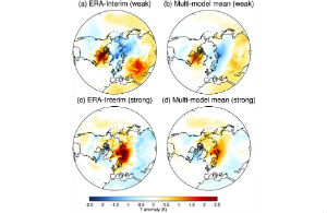
The strength of the polar vortex, a ribbon of air that orbits the Arctic, is also known to influence extreme weather patterns in these regions. This includes weather connected with Sudden Stratospheric Warmings, which allows bitterly cold Arctic air to escape southwards when the polar vortex weakens.
The researchers argue that representing variations in the stratosphere in more detail would allow forecasting models to provide more accurate predictions. Improving early predictions for the stratosphere could also provide significantly improved weather forecasts further in advance.
Futher work needed
A key part of the work was the significant international collaboration involved, examining models and scientists from a number of different countries. Dr Frederic Vitart, Principal Scientist at ECMWF and co-chair of the S2S project, said: "The two articles represent a key contribution to the joint World Weather Research Programme (WWRP) and World Climate Research Programme (WCRP) S2S Prediction Project by exploiting the S2S database to assess the current skill of the state-of-the-art models to predict stratospheric processes and their impact in the troposphere.
“They demonstrate the power of the S2S database for discovering new stratospheric sources of weather forecasting potential up to several weeks ahead and illustrate the strong links between the S2S forecasting and stratospheric research communities."
The work was undertaken as part of the Stratosphere-Troposphere Processes and their Role in Climate (SPARC) programme, which co-ordinates efforts to bring knowledge of the atmosphere to bear on issues regarding climate variability and prediction.
Dr Judith Perlwitz, SPARC co-chair, said: “These two articles highlight the large possible benefit to weather prediction of further targeted research to improve our ability to model and observe the stratosphere.”
Dr Amy Butler, CIRES/NOAA research scientist, said: "While this study clearly demonstrates the importance of stratospheric information for extended range forecasts, it also motivates further work on understanding when and where the stratosphere adds the most value to predictive skill."
Full paper references
Domeisen, D., Butler, A., Charlton-Perez, A., Ayarzagüena, B., Baldwin, M., Dunn-Sigouin, E., Furtado, J., Garfinkel, C., Hitchcock, P., Karpechko, A., Kim, H., Knight, J., Lang, A., Lim, E., Marshall, A., Roff, G., Schwartz, C., Simpson, I., Son, S., Taguchi, M. (2019); ‘The role of the stratosphere in subseasonal to seasonal prediction Part 1: Predictability of the stratosphere; Journal of Geophysical Research; doi: 10.1029/2019JD030920
Domeisen, D., Butler, A., Charlton-Perez, A., Ayarzagüena, B., Baldwin, M., Dunn-Sigouin, E., Furtado, J., Garfinkel, C., Hitchcock, P., Karpechko, A., Kim, H., Knight, J., Lang, A., Lim, E., Marshall, A., Roff, G., Schwartz, C., Simpson, I., Son, S., Taguchi, M. (2019); ‘The role of the stratosphere in subseasonal to seasonal prediction Part 2: Predictability arising from stratosphere - troposphere coupling’; Journal of Geophysical Research; doi: 10.1029/2019JD030923
Image caption: Images of weak and strong vortex states considered in the research
